Llanganuco Lake with its glacial waters and massive rock faces hiding 22,500' Mt Huascaran.
We were the last people out of the park and when we arrived at the gate, it appeared locked. Jan managed to 'leverage' the two large rocks that allowed for the wooden pole to left and we were 'free'.
Above Lago Paron the rock just seems to continue up and up. One wonders about the forces of nature when faced with such massive amounts of rock. I wanted to go climb but quickly lost that fantasy.
Trying to get another view of some of the bigger peaks, we took a road that was under construction but the clouds obscured the massive peaks leaving us to wonder what was there that we wern't seeing.
When I come across a road sign that warns me the road is only 10 feet wide(with no shoulder)and trucks come screaming around the corner, my heart starts racing. But it was a beautiful view!
I am constantly amazed at what amount of energy it takes for a road to be built and even more to be maintained in a very unstable area.
Farming patch work quilt style is seen in the forground. We explored up the canyon to the left with almost vertical walls.
After an incredible week of varied weather conditions (all without rain!) which allowed peekaboo views of some of the mountains (up to 22,500 feet) we left the valley this morning feeling grateful for what we did see. The best time to visit is in April.May,June when skies are crystal clear and it is warmer in the day and colder at night. We loved the climate as we found it- mild and comfortable at 5-7,000'. At 13,000 we got winded even getting off and on the motorcycle. It was worth it- breathtaking I think is the word. Here are a few shots taken over this past week.
Friday, December 7, 2012
Thursday, December 6, 2012
THE ROADS of NORTHERN PERU/ Dec. 2012
Roads wind and twist snaking their way up the side of the mountain. At least you can see the oncoming cars and trucks for miles.
So far travel has been slow. Like 10 mph on the average on dirt roads. Today we went 100 kms.(62 miles) and it took 3 1/2 hours and I was exhausted. My riding skills have improved though I wish I had taken some off road riding courses before starting the trip. Most of these difficult conditions are the result of road work to improve narrow and inadequate dirt roads prone to slides, washouts and other changes.Irregular road surfaces are caused by big trucks and loose soil. This can mean deep ruts that fill with water.
My biggest fear is mud. Today I got plenty of it, more than I would wish on anyone. Why? Well, two wheels in line don’t give the stability that three or four do and riding in mud can be most like being on a frozen lake when you can’t get any traction or the mud dictates which way your tire goes, not you.Sometimes the mud is like a thick chocolate shake and other times like a soft fudge. Today I went through some Big mud holes or ponds without knowing how deep they were. There was no way around so you just giver some more gas and lighten up on the steering and let the front wheel kinda move on its own. Remember to keep your balance! I have learned to find my line and follow it. Once committed you go for it and you go faster than slower- just maybe the speed will get you through if the traction doesn’t. Anyway, a drop in a mud hole can’t be all that bad, now can it? I don’t want to go there.
My next biggest fear is being on a narrow road cut out of a hillside with a drop a 1,000 on my right and a deep ditch on my left and a big truck coming. I usually don’t have time to sight see and look over the edge as I’m moving along the wet or dry bumpy road but I do catch a glimpse of a sheer drop and wonder how many times the bike would bounce as it careens down the face of the cliff…
Backstory
My Grandfather for whom I was named was always spoken of with the utmost regard. One of several children raised in the town of Bridlington, England along the shore of the North Sea in a tiny seaside resort, the family had a number of properties in town and it was expected that Edwin would continue his studies at University. This was the time when the British Empire had an expanded presence in the world and 'the sun never set on the empire'. It was also the custom of a young British gentleman to go and see the world. This is what Edwin did. He left his university studies, asked for a yearly stipend and set out. He returned 14 years later. My mother remember only a few stories of his adventures of travels but they were always told with great admiration.
So it is within this context that my mother who named me after her father always said,' Oh, if your Grandfather could see you now' or 'You look just like you're Grandfather'.
This was fortunately for me a positive connotation. For others who carry the name of a Grandparent it can be negative. This 'social grooming' with its built in expectation that you'll amount to something like your Grandfather made it easy for me to be supported in my early adventures to Mexico in 1963 and Guatemala in 1964 and Mexico again in 1965. Obviously the world was a different place then than now. Few people ventured south of the border very far and fewer still attempted to drive a car to Belize, British Honduras (as known at that time). There were no guide books at that time other than the famous South American Handbook which was published every couple of years and which was helpful but contained little information on available hotels and lodging. One just made your own way, asked around and found what little was available. No travelers infrastructure had yet been developed to make trips readily available. It was much more challenging to get information on road conditions and telephone communications were problematic at best, especially in the more remote areas.
Move forward to now. I'm in central Peru. Seeing places I haven't seen in thirty years and some I've never seen. Having fun and a flight of emotion that ranges from happy to scared. I go around a corner on a mountain road not big enough for a truck and a motorcycle to pass and I think: "Whoa" That is a 1000 foot drop and I'm so close to it". Beats wondering what next to do with my life.
So it is within this context that my mother who named me after her father always said,' Oh, if your Grandfather could see you now' or 'You look just like you're Grandfather'.
This was fortunately for me a positive connotation. For others who carry the name of a Grandparent it can be negative. This 'social grooming' with its built in expectation that you'll amount to something like your Grandfather made it easy for me to be supported in my early adventures to Mexico in 1963 and Guatemala in 1964 and Mexico again in 1965. Obviously the world was a different place then than now. Few people ventured south of the border very far and fewer still attempted to drive a car to Belize, British Honduras (as known at that time). There were no guide books at that time other than the famous South American Handbook which was published every couple of years and which was helpful but contained little information on available hotels and lodging. One just made your own way, asked around and found what little was available. No travelers infrastructure had yet been developed to make trips readily available. It was much more challenging to get information on road conditions and telephone communications were problematic at best, especially in the more remote areas.
Move forward to now. I'm in central Peru. Seeing places I haven't seen in thirty years and some I've never seen. Having fun and a flight of emotion that ranges from happy to scared. I go around a corner on a mountain road not big enough for a truck and a motorcycle to pass and I think: "Whoa" That is a 1000 foot drop and I'm so close to it". Beats wondering what next to do with my life.
Dec. 3 -Lago Llanganuco, Peru
I've been here before. Many years ago. Another life. A good one but still... awhile ago. Lago Llanganuco has suffered a warped reputation. On May 31, 1970 an earthquake shook the whole valley of Callejon de Huaylas causing severe damage to many communities, most especially the one lying at the outflow of what would become one of the major tragedies on the 20th century in the western hemisphere. Yungay happened to receive the most severe damage to both structures and life. As the major earthquake shook the whole region, it dislodged a large chunk of rock and ice from Mt. Huascaran. Cascading down the sloop and creating a landslide of immense proportion the rock and ice fell into Lago Llanganuco causing an overflow of the lake that rushed down the hillsides and literally burying the town of Yungay. The few that escaped had been at the cemetery which was located on a hilltop above the town. 20,000 people were killed, the town buried and to this day it remains a 'campo santo' or dedicated holy ground.
Lago Llanganuco is actually two lakes nestled between tall flanks of rock faces that jut up several thousand feet only to be backed up by even higher peaks in the 18-20,000' range. It is a spectacular site and awe inspiring on a clear day.
Our journey today by motorcycle was to check out the road and try and determine if we could do the two day trip up the canyon, up the sides of the mountains, over the 16,000' pass and down and around other mountains returning via another dirt road the next day. Our first look was not promising and speaking with truck drivers coming over the pass from the jungle they said they had to sleep in their truck awaiting a bulldozer to clear the road so they could pass. doesn't sound like my kind of fun on a motorcycle. Here are some pictures of the area.
Lago Llanganuco is actually two lakes nestled between tall flanks of rock faces that jut up several thousand feet only to be backed up by even higher peaks in the 18-20,000' range. It is a spectacular site and awe inspiring on a clear day.
Our journey today by motorcycle was to check out the road and try and determine if we could do the two day trip up the canyon, up the sides of the mountains, over the 16,000' pass and down and around other mountains returning via another dirt road the next day. Our first look was not promising and speaking with truck drivers coming over the pass from the jungle they said they had to sleep in their truck awaiting a bulldozer to clear the road so they could pass. doesn't sound like my kind of fun on a motorcycle. Here are some pictures of the area.
A New Start. I'm hoping Blogspot will help me get my message out with photos!
I'm trying to get high (not in the 60's sense) up the side of Huscaran which is the 4th highest mountain in the western hemisphere at 22,204. This part of Peru allows for high elevation trips on questionable roads that expand into awe inspiring scenery. I'm lucky enough to have a day relatively clear of cloud cover. I got to 15,000' before I had to turn back but not before marveling at natures beauty. I had to pinch myself since satiation is so easy. We always have beauty around us but often take it for granted or it takes someone else to help us see it anew.
Saturday, November 3, 2012
ECUADOR- the High Country Nov. 3rd
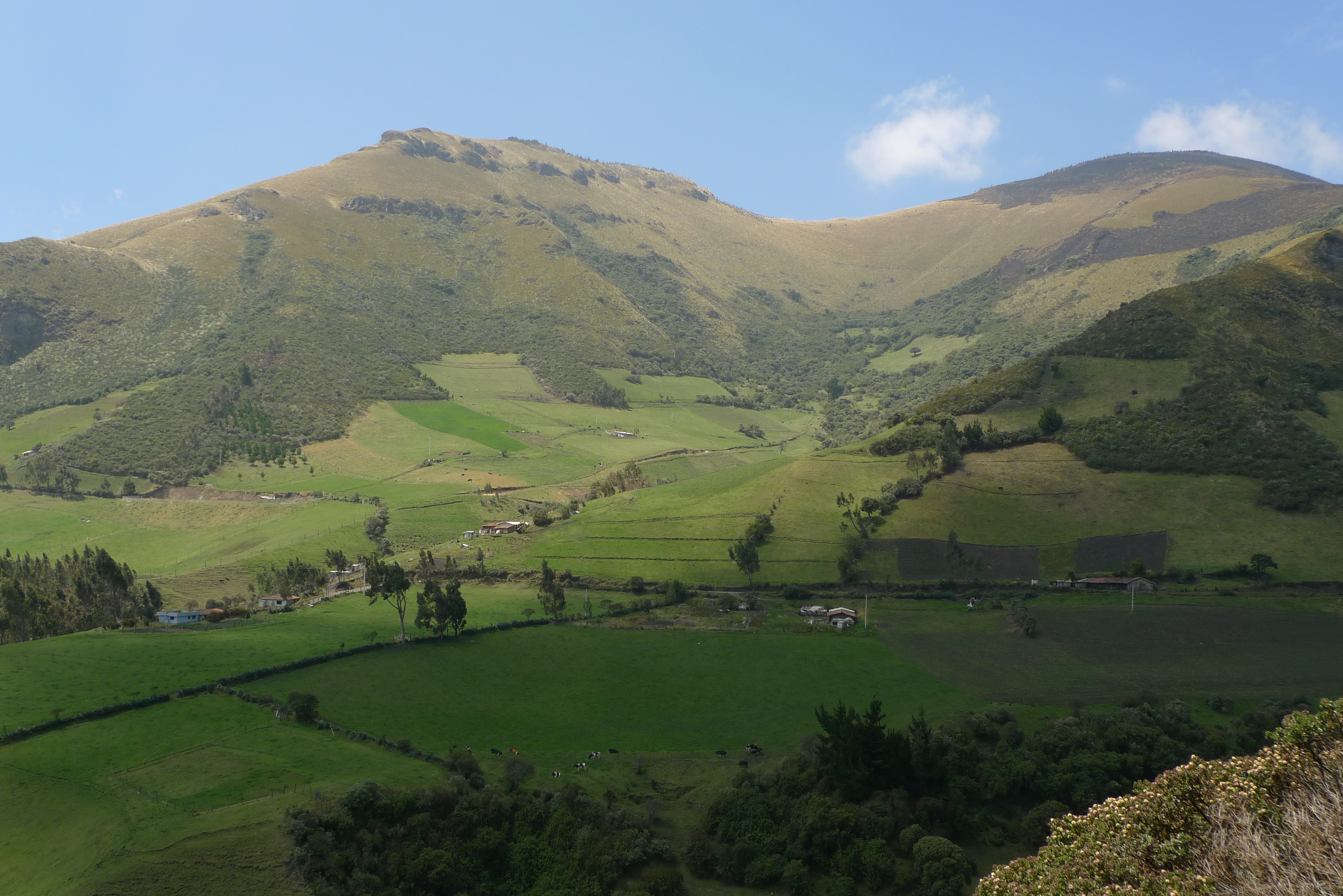
Ecuador is the size of Colorado yet it has an amazing diversity- from expansive coastal beaches to even more expansive jungle opening on to the great Amazon basin. Between these two geographical extremes lies country at many different altitudes where most of the people live. While it is not impossible to find people living at 13,500' it is not the best environment to eek out a living. Tubers will grow and some small animals will get by but for me I love the 11,000-13,000 foot elevation. Why? Many of the rolling hills and open expanses are at this altitude and just invite a stroll through tall grass. It is oftentimes raw with questionable weather. You can start out in the am with warm sun, yet with a thinness in the air. The cloud covers the sun, the temperature drops, the cloud passes the sun and warmth returns. The wind come up, you hunker down, the changing landscapes from clouds passing shifts the colors and creates magic.
It can and does happen everywhere. In your place also. It all happens so fast we tend to miss it unless we bundle up and strike out. Here are some shots.
[caption id="attachment_508" align="alignnone" width="1024"]
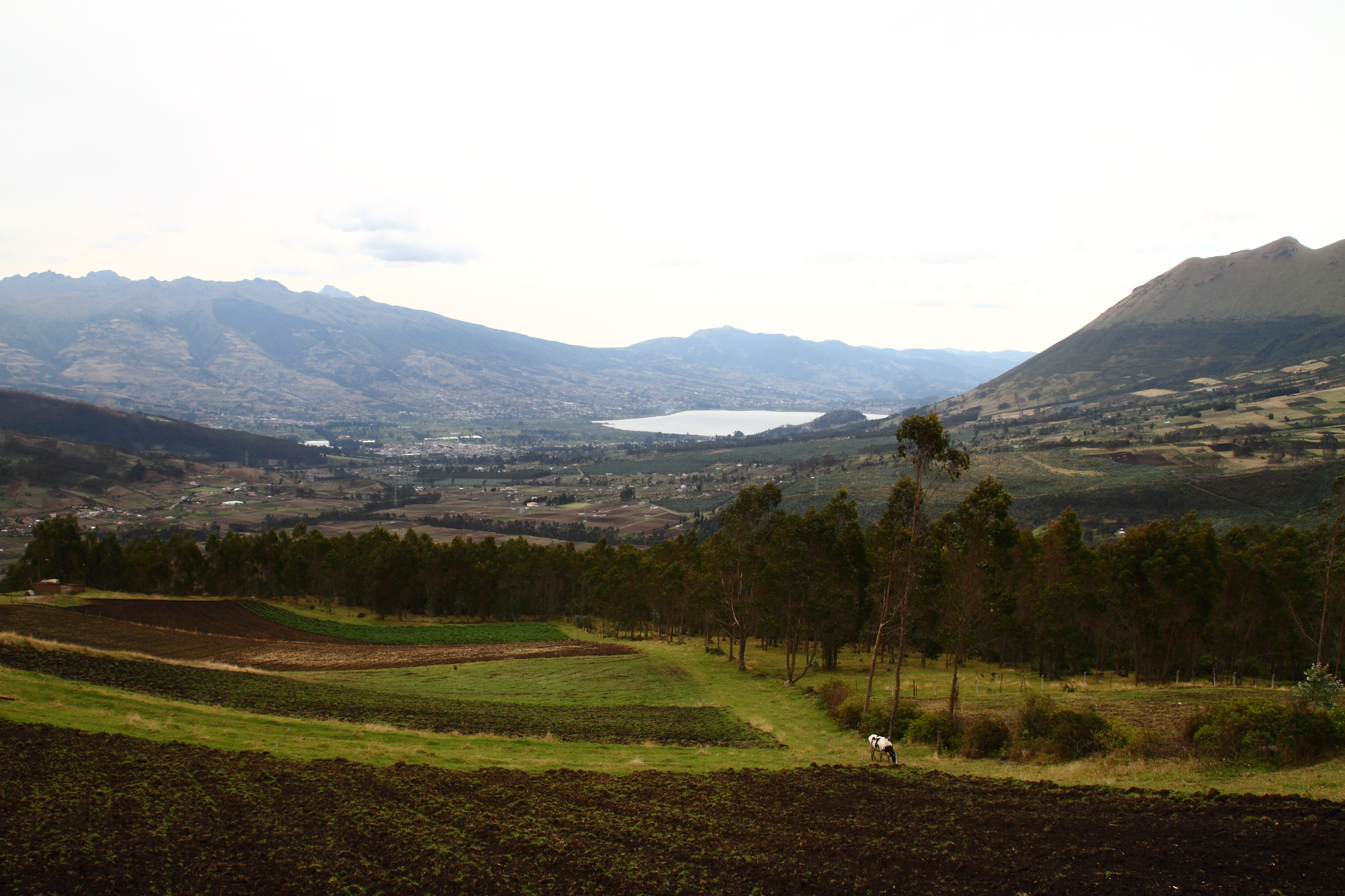
lower elevation looking out over former hacienda lands returned to indigenous peasants in the 1950's as part of a re distribution program.
It can and does happen everywhere. In your place also. It all happens so fast we tend to miss it unless we bundle up and strike out. Here are some shots.
[caption id="attachment_508" align="alignnone" width="1024"]
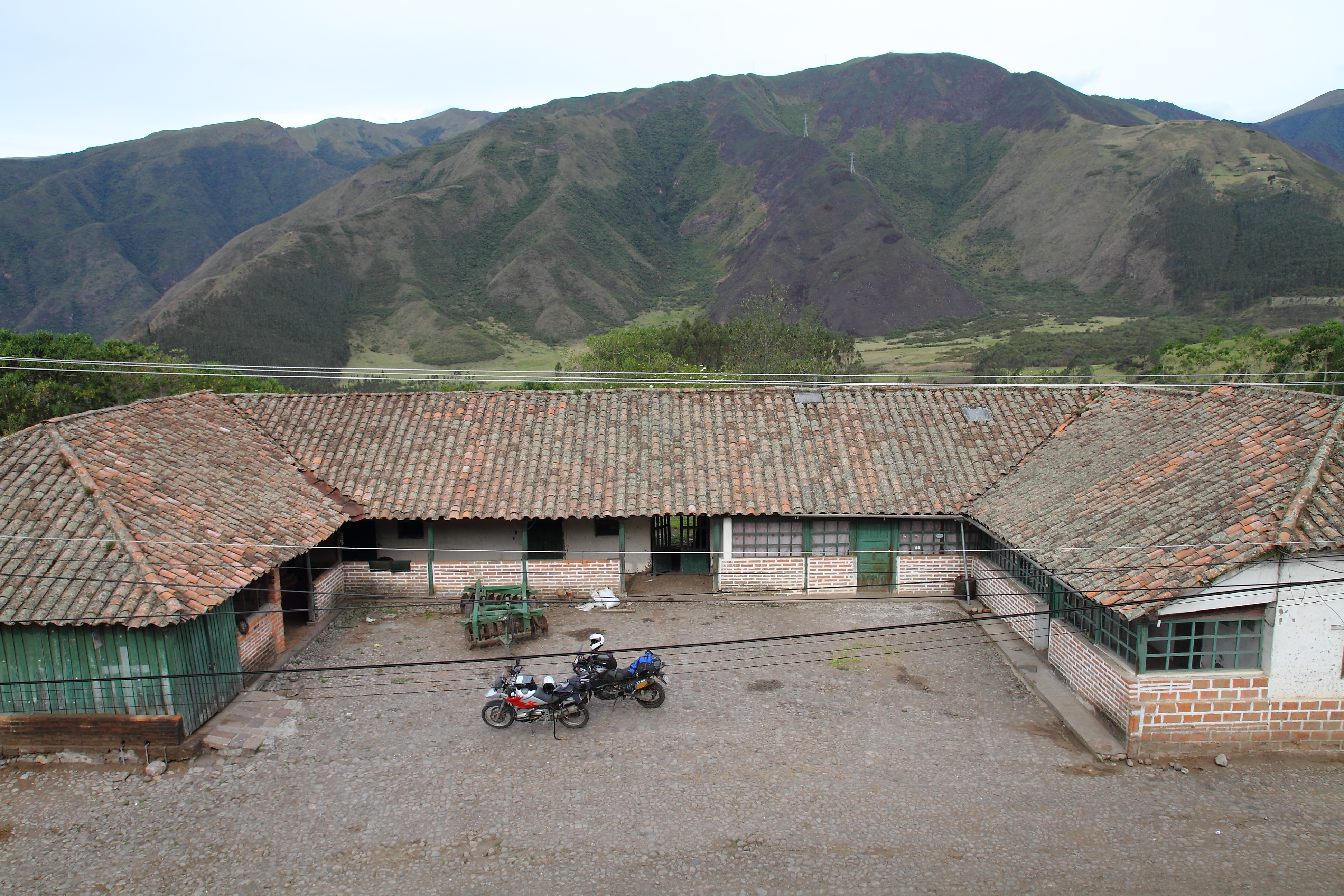
- The farm houses of the Hacienda La Magdalena a magnificent structure just purchased by 87 partners (all indigenous farmers who have always lived and worked on the farm(sounds like middle age surfdom?) Right. With over 400 acres of fertile land the main house(not shown) is designated for tourist use.
Wednesday, October 31, 2012
Quito, ECUADOR-Colonial Center- a brief detour
Quito has the largest identifiable colonial center in Latin America. It has the famous designation as a World Heritage Site and as such must restrict development, renovation,painting and change to maintain it's status. What I find remarkable about this colonial center of town is that it is still a vibrant, lower working class environment that has been cleaned up. It has only one street, La Ronda, that has received, in my opinion, undue sanitary whitewashing to the point of museum. Others might not agree but then,this IS my Blog. Over the years, drunks and prostitutes have been removed, streets closed to traffic which makes this a walking friendly area. Social police are present to offer directions and be helpful. Guns and rifles are not visible. Something else isn't very visible. Hole in the wall restaurants that cater to the lunch crowd. Seating between 4-8 tables 'cheek to jowl' I had a lunch that cost me $2.00. A large glass of juice, a large bowl of tasty soup, a plate full of rice,beans, a slice of plátano,and several pieces of cooked pork. $2.00, just like we remember it when we travelled 20-30-40 years ago. Gas is $1.46 regular. Enough. Back to Colonial Quito. A few pictures of the vibrant area at 10,000' and an interior that is old.
[caption id="attachment_501" align="alignnone" width="1024"]
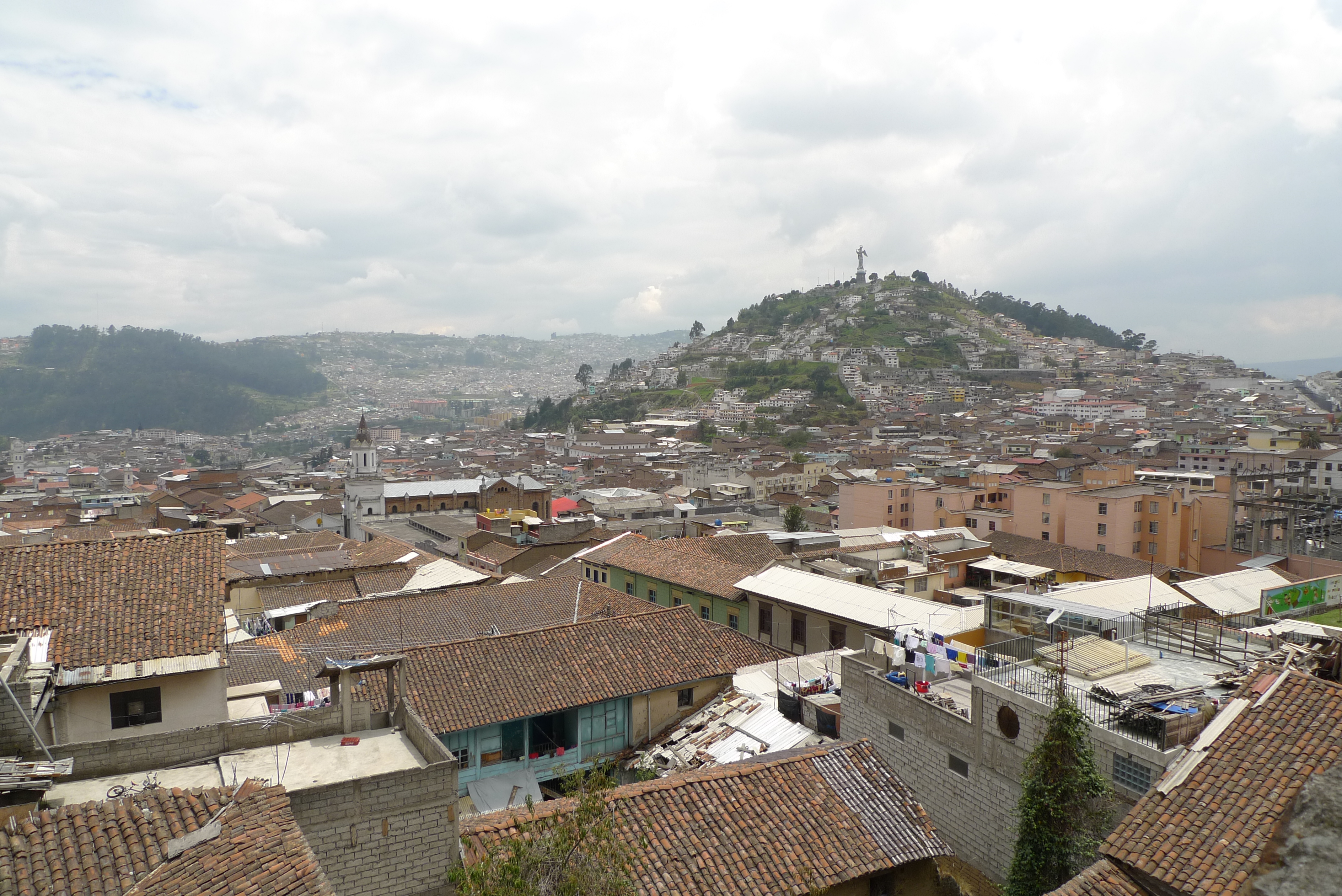
looking over colonial Quito toward el panacillo (the breadloaf'
[caption id="attachment_501" align="alignnone" width="1024"]
- another view
- note how the string is lashed around a supporting timber, interwoven around the bamboo. Age unknown but must be over 150 years old and still holding strong.[/caption]
- a contrast between a ceiling that is old and hand painted and the substrata that is supporting the ceiling. It is bamboo held together with 'cabulla' a string made from a plant in the maguey family.
Subscribe to:
Posts (Atom)